


LEE COUNTY, Fla. — During an interview with Fox 4, Lee County Manager Roger Desjarlais stood by the county's evacuation timing, despite readily available National Hurricane Center and National Weather Service (NWS) data indicating an imminent threat.
“I'm comfortable with the decisions that were made and the timing,” Desjarlais said.
Lee County’s own Emergency Management Plan, called CEMP, says if there is a 40 percent chance or greater of four feet of storm surge, coastal Zone A should be evacuated.
On Sunday night at 11 p.m., 64 hours before Hurricane Ian made landfall, the NWS issued a Tropical Storm Watch.

The NOAA storm surge models showed a 50%-69% chance of at least four feet surge and a 40%-49% probability of at least a six-foot surge.
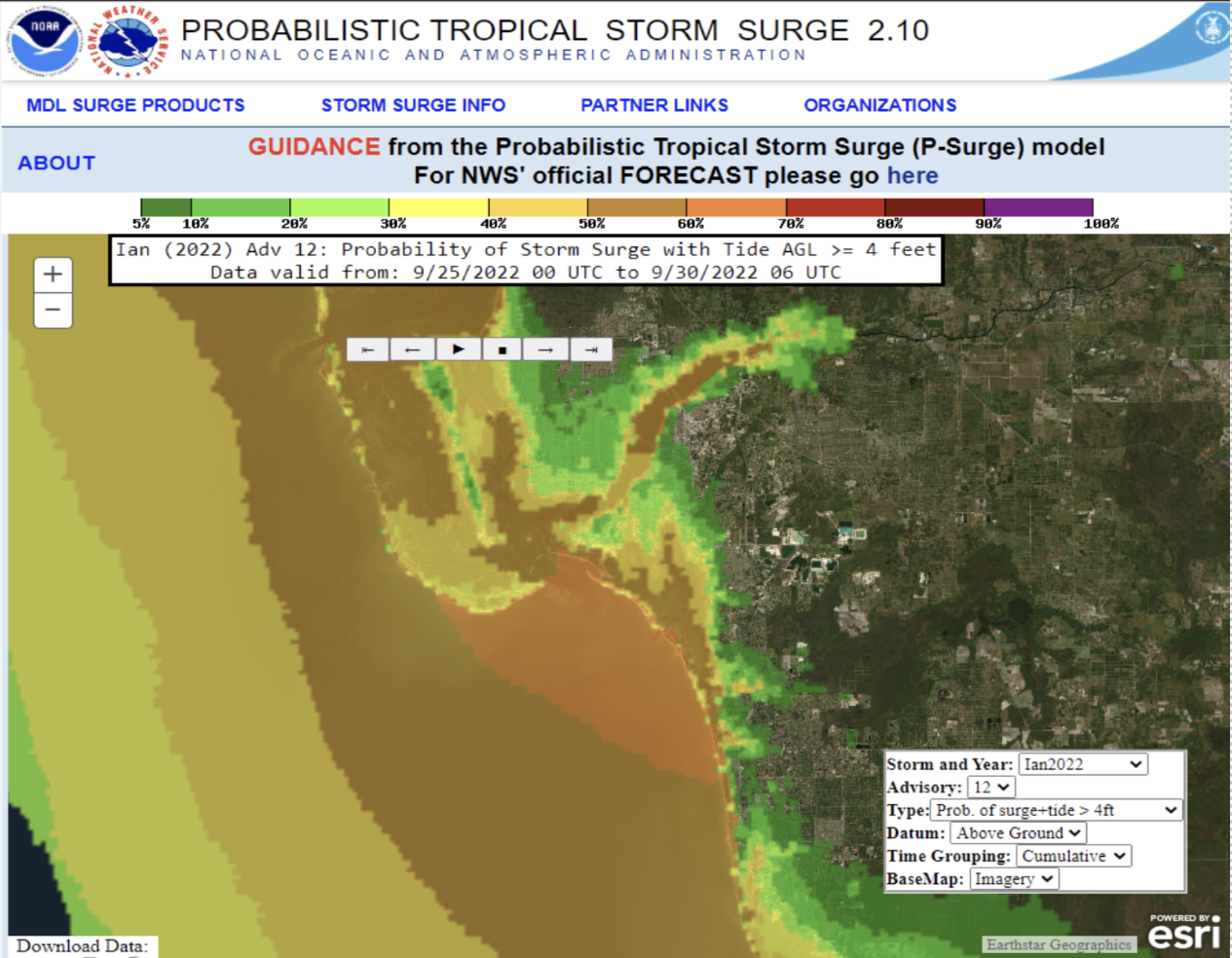
Which continued into Monday morning, Sept. 26 at 11 a.m.
That was the data available to now designated decision maker Desjarlais as he headed into his Sept 26, 3 p.m. news conference, when he said county leaders were not yet making any evacuation decisions.
“If you’re feeling unsafe, if you’re feeling a little nervous about this storm and about the effects, it’s OK to go now,” Desjarlais told barrier island residents during the Sept 26th news conferences.
Four hours later, at 7:03 p.m., Lee County Public Information Officer Betsy Clayton emailed several county staff members a draft of the evacuation order and press release.
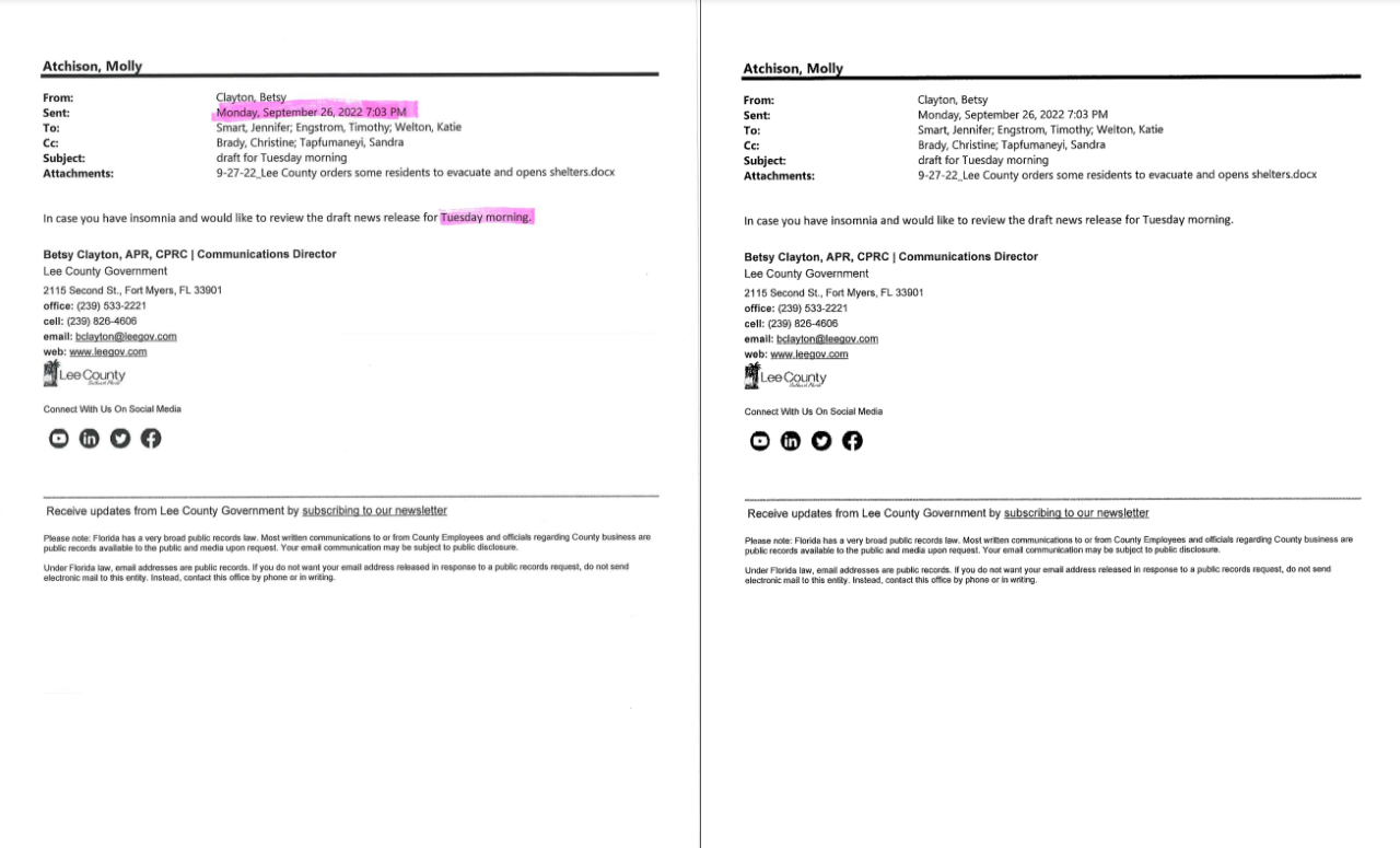
However, that order was not released to the public for 12 more hours.
The first evacuation came the next morning, Tuesday, Sept. 27.
During a 7 a.m. news conference, Desjarlais’ tone had a noticeable change when he announced Zone A, including Fort Myers Beach, and parts of Zone B in Cape Coral, was being evacuated.
“As mandatory as can be,” Desjarlias said, continuing to talk about “The importance of people getting out of harm's way based on the surge models.”
“That morning it’s like OK, now it’s coming,” survivor Mike Yost said, comparing his concerns about Desjarlais' change in tone compared to Monday’s message. “It did not feel like that had a sense of urgency.”
Lee County leaders say the 7 a.m. news conference gave residents in Zone A, including Fort Myers Beach, Sanibel, Captiva, and parts of Zone B in Cape Coral 32 hours to evacuate before Hurricane Ian made landfall.
Which the National Weather Service defines as the center of a hurricane’s eye moving over land.

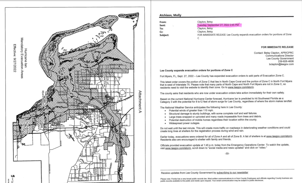
There was even less evacuation time when Desjarlais announced all of Zones B and C had been added to the evacuation orders by a 2 p.m. news conference.
However, Southwest Florida ultimately started seeing Ian’s impact long before the storm’s 35-mile-wide eye touched Lee County.
For instance, the National Weather Service says 40 miles per hour tropical storm winds and rain were observed at 11 p.m. Tuesday night, just 16 hours after the first evacuation was issued.
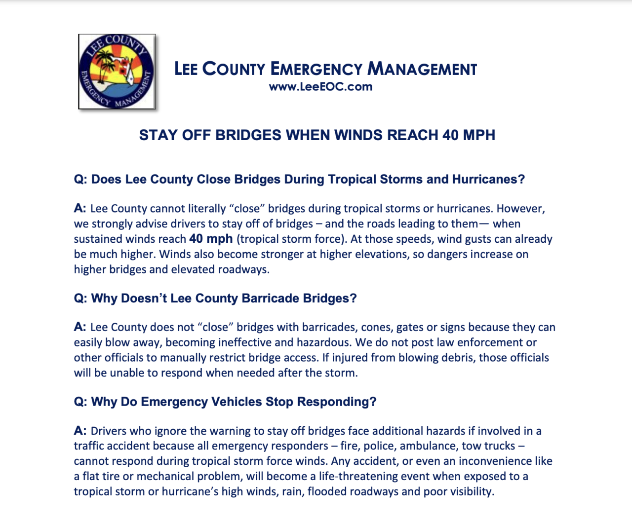
During this time, Lee County leaders strongly recommended not driving on bridges, once tropical storm force winds reach, and sustain, at 40 miles per hour or higher.
Which are the only evacuation route for parts of Zones A and B.
Bridges often present one of the biggest challenges when planning coastal communities and barrier island evacuations.
The Southwest Florida Regional Planning Council’s 2010 Evacuation study says it takes 20 hours to entirely evacuate Lee County Zones A, B, and C.
That does not account for the massive growth our area has seen since 2010.
Despite the warning not to drive on bridges, by 6 a.m. Sept. 28, Fox 4 cameras captured people trying to evacuate on the Sanibel Causeway.
“You can just see how slow a car is going at this time,” Fox 4’s Elyse Chengeary reported.
As early as 9 a.m. Wednesday, Fox 4’s own meteorologists tracked the Estero Island surge.
Around the same time, when Ian was at its strongest, reaching a Category 5 in the Gulf, Mitch Pacyna’s own video already showed a storm surge on Fort Myers Beach.
“I’ve never seen a river floating down my street,” Pacyna said around 10 a.m.
By the 32-hour mark, from the time when the County issued the first evacuation order and when Ian’s eye Ian made landfall at 3:05 p.m. Wednesday, half of the storm was already on shore.
While weather experts warn nighttime evacuations can be dangerous, National Weather Service Warning Coordination Meteorologist Daniel Noah provided an analysis of the Lee Co. leader's evacuation call.
“In hindsight could you have made the call a day earlier? “Of course. We did that up in Tampa,” Noah said.
“All of those studies that you see and charts that you see calling for evacuation times, that's a place to start. That's not the final decision point,” Desjarlais responded when Fox 4’s Nadeen Yanes asked him about the county’s emergency management plan’s evacuation map.
“And you said the 32 hours before it made landfall is when the evacuation was first put in place. But it was about 15 hours before we felt Ian and as we know that storm surge came in the morning before landfall at three o'clock,” Yanes asked Desjarlais.
“Well you know, I'm not, the message was still correct. And the time was still correct,” Desjarlias responded.
Watch Now: Extended Interview with Lee County Manager Roger Desjarlais


