Weather

Actions

FORECAST: Heat Advisories again today, stormy evening expected

Heat index values will once again climb to as high as 110° is some areas
Heat continues to be an issue in Southwest Florida
Posted
and last updated

Here is your forecast for Wednesday, August 6th, 2025.
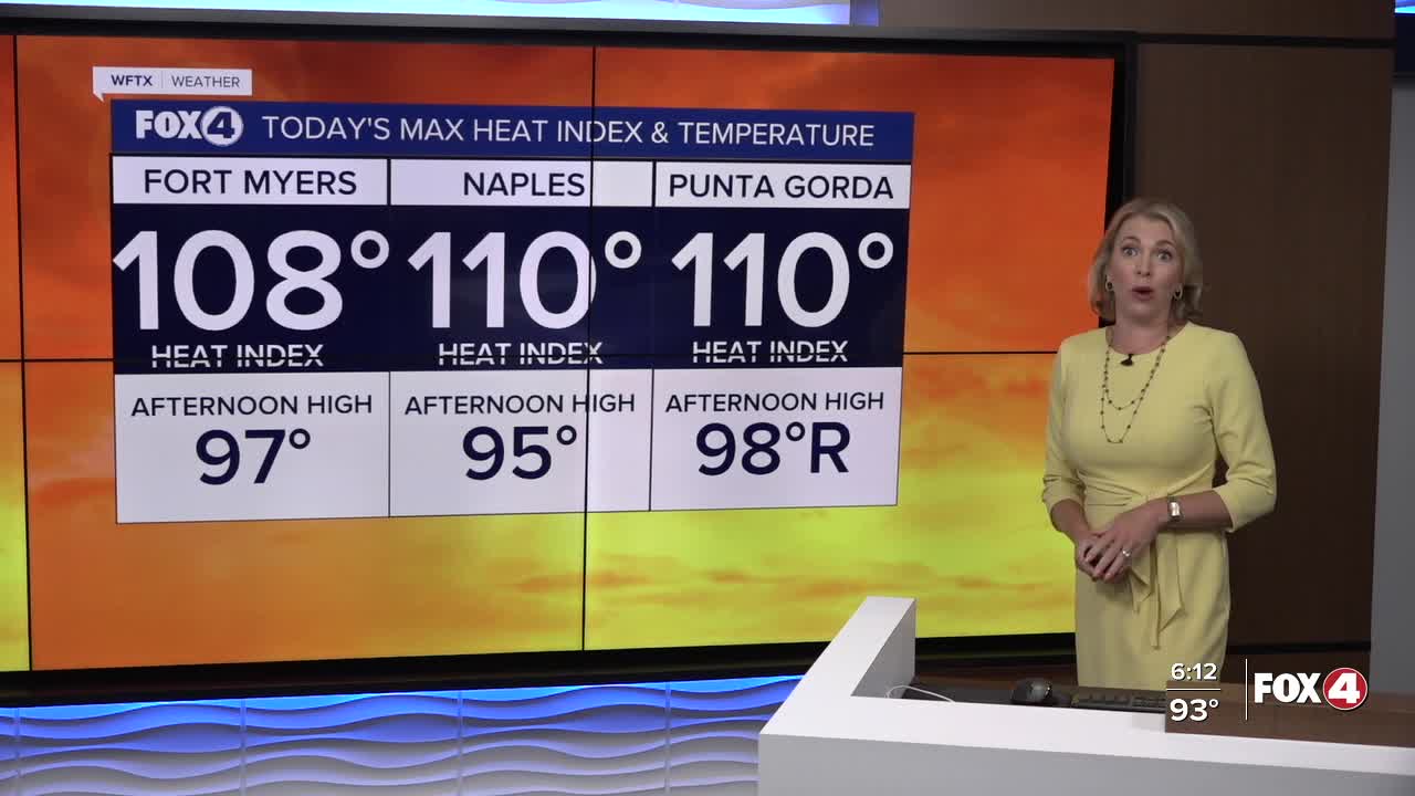
Good morning, Southwest Florida!

We are waking up warm and dry this morning with temperatures in the mid to upper 70s which is near our average of 75° for this time of the year. This afternoon we will climb in the mid 90s and once you factor in the humidity some areas inland will see heat index values as high as 110°. A Heat Advisory is in place for Glades, Hendry and Collier counties from 11AM until 7PM this evening.
The chance of rain comes up to 80% today as showers and storms will be more widespread and also a little later in the day. Those showers and storms will start to build around 4PM-5PM and be at their strongest around between 6PM-8PM. The showers and storms could linger past sunset but be down by midnight.

The chance of rain is around 60-70% tomorrow as the showers and storms continue to move on an east to west flow across the state. Highs will once again be in the mid 90s before the storms arrive in the afternoon.

In the tropics, the National Hurricane Center is issuing advisories on Tropical Storm Dexter which continues to move safely east north of Bermuda. This storm will continue to move away from the United States and will not be an issue for Southwest Florida. We are monitoring two other areas in the Atlantic.

1. A tropical wave over the far eastern tropical Atlantic is currently producing minimal shower activity. Environmental conditions are expected to be conducive for gradual development during the next few days, and a tropical depression could form late this week or over the weekend as the system moves generally west-northwestward across the central tropical or subtropical Atlantic.

Formation chance through 48 hours is low near 20 percent.
Formation chance through 7 days is medium at 60 percent.

2. A weak surface trough located several hundred miles off the coast of the southeastern United States is producing scattered showers and thunderstorms. An area of low pressure is expected to develop from this system over the next day or so, and environmental conditions appear generally favorable for additional development. A tropical depression could develop late this week or this weekend as the low drifts westward before gradually turning northward to northeastward by the weekend.

Formation chance through 48 hours is low near 10 percent.
Formation chance through 7 days us medium at 40 percent.

FOX 4 MORNING METEOROLOGIST TRENT ARIC


If you don't already have our Fox 4 mobile app, you can download it here.