


UPDATE 8/17/21 5AM
Fred weakens to a Tropical Depression this morning as it moves over the Alabama and Georgia state line.
On the forecast track, the center of Fred will move across western and northern Georgia today, across the southern Appalachian Mountains tonight, and into the central Appalachians by early Wednesday. Maximum sustained winds have decreased to near 35 mph with higher gusts. Additional weakening is forecast during the next couple of days and Fred is expected to degenerate into a remnant low by tonight and merge with a frontal system on Wednesday.
The estimated minimum central pressure based on nearby surface observations is 1004 mb.
FOX 4 MORNING METEOROLOGIST TRENT ARIC
UPDATE 8/16/21 11 PM
Winds are now down to 40 mph and it will likely become a tropical depression by the 2 AM or 5 AM advisory. The storm will track toward Atlanta Tuesday afternoon with a threat for tornadoes on the east side of its circulation from NE GA through the Upstate of SC into NC and Virginia.
FOX 4 CHIEF METEOROLOGIST DEREK BEASLEY
UPDATE 8/16/21 8 PM
Fred is weakening as it lifts northward through the Florida Panhandle. It is near Marianna in Jackson Co. and will enter Alabama near Dothan by 10 PM Eastern. Winds are now down to 50 mph and is moving NNE at 10.
FOX 4 CHIEF METEOROLOGIST DEREK BEASLEY
UPDATE 8/16/21 5PM
Fred made landfall earlier this afternoon at 315 with winds of 65 mph near Cape San Blas FL. The storm will continue moving inland tonight and will weaken quickly. The threat for heavy rain and tornadoes will spread inland overnight into south Georgia. Some areas could see over 8" of rain and flooding will be likely especially in the heavier rain bands.
FOX 4 CHIEF METEOROLOGIST DEREK BEASLEY
UPDATE 8/16/21 2 PM
The intermediate update from the NHC indicates T.S. Fred has gotten stronger with 65mph winds now moving NNE at 9mph. As of 2pm, it was located only 35 miles SW of Apalachicola. Conditions are deteriorating along the panhandle with gusty winds & rain. Banding does extend down the Florida coast with a few showers & storms off the Sarasota coast. Fred. is forecast to make landfall within the next 3 hours.
FOX 4 METEOROLOGIST CINDY PRESZLER
UPDATE 8/16/21 11 AM
Tropical Storm Fred has become better organized this morning but winds are still at 60mph. It could strengthen just a bit yet before making landfall today near Apalachicola in the Florida panhandle. Impacts will be widespread including heavy rainfall, flooding, & wind. Non will affect SWFL.
FOX 4 METEOROLOGIST CINDY PRESZLER
SPECIAL UPDATE 8/16/21 8:30 AM
Hurricane Hunter find Fred intensifying and located a little farther east.
Data from an Air Force Reserve Hurricane Hunter aircraft indicate that Fred is intensifying this morning, and now has maximum sustained winds near 60 mph, with an estimated minimum central pressure of 993 mb. Data from the aircraft and National Weather Service Doppler radar indicate that Fred is now moving toward the north at 10 mph.
FOX 4 MORNING METEOROLOGIST TRENT ARIC
UPDATE 8/16/21 8 AM
Fred now 90 miles SSW of Apalachocola, Florida and moving north at 9mph.
Maximum sustained winds are near 50 mph with higher gusts. Some strengthening is forecast before landfall. After landfall, Fred is expected to quickly weaken. Tropical storm force winds extend outward up to 90 miles from the center. The estimated minimum central pressure is 1002 mb.
FOX 4 MORNING METEOROLOGIST TRENT ARIC
UPDATE 8/16/21 5 AM
Tropical Storm Fred moving northward toward the Florida panhandle bringing heavy rainfall. Dangerous storm surge expected along the coast of the Florida panhandle and big bend later today.
On the forecast track, the center of Fred should move across the northeastern Gulf of Mexico today, and make landfall in the western Florida Panhandle this afternoon or early evening. Maximum sustained winds remain near 50 mph with higher gusts. Some strengthening is forecast before landfall. After landfall, Fred is expected to quickly weaken. Tropical storm force winds extend outward up to 90 miles from the center. The estimated minimum central pressure is 1002 mb.
FOX 4 MORNING METEOROLOGIST TRENT ARIC
UPDATE 8/15/21 11 PM
Tropical Storm Fred is a little stronger with maximum sustained wind of 50 mph as it moves to the NNW at 9 mph. Central pressure has now dropped to 999 mb. Tropical storm force wind remains up to 90 miles from its center. Even though Fred is experiencing moderate southwesterly wind shear it is expected to strengthen a bit more before making landfall. Fred is expected to pack wind of 60 mph when it makes landfall late Monday.
FOX 4 METEOROLOGIST ERIC STONE
UPDATE 8/15/21 8 PM
Tropical Storm Fred continues to pack maximum sustained wind of 45 mph with tropical storm force wind extending 90 miles to the east. It is now 205 miles WSW of Tampa and continues to move to the NNW at 10 mph away from SWFL. Fred is expected to become a bit stronger before making landfall in the panhandle Monday evening. Rain continues to fall along our coast this evening with stronger storms offshore.
FOX 4 METEOROLOGIST ERIC STONE
UPDATE 8/15/21 5 PM
Tropical Storm Fred now has maximum sustained wind of 45 mph with tropical storm force wind extending 90 miles to the east. It is 190 miles WSW of Tampa and continues to move to the NNW at 10 mph. Low level circulation has become better defined as Fred appears better organized with convection banding around its center. With moderate wind shear there is a chance Fred could get a bit stronger before making landfall in the panhandle Monday evening. Light rain continues to fall on our coast with typical rainy season scattered showers and storms moving through.
FOX 4 METEOROLOGIST ERIC STONE
UPDATE 8/15/21 2 PM
Tropical Storm Fred continues to move to the NNW at 12 mph. We don't see much change in Fred as it continues to pack wind of 40 mph with minimum central pressure of 1007 mb. Fred is expected to gain some strength as it makes landfall in the panhandle around Pensicola late Monday. Showers and storms will continue to move through SWFL with most of the rain from Fred remaining offshore.
FOX 4 METEOROLOGIST ERIC STONE
UPDATE 8/15/21 11 AM
Tropical Storm Fred is now moving to the NNW at 12 mph and remains a minimal tropical storm with maximum sustained wind of 40 mph. Fred is expected to gain some strength over warm Gulf water and an environment of moderate vertical wind shear. Fred is expected to make landfall late Monday as a 50 mph tropical storm then quickly dissipate as it makes its way to the Tennessee valley bringing several inches of rain to that region. Fred continues to bring rain into Southwest Florida this morning and into the afternoon, but the brunt of its moisture is well offshore. Tropical storm force wind extends up to 80 miles away from its center, but Fred remains much further away from our region.
FOX 4 METEOROLOGIST ERIC STONE
UPDATE 8/15/21 9 AM
Fred has regained tropical storm status. Hurricane hunter aircraft flying in the storm determined that Fred now has a closed area of low pressure classifying it as a tropical cyclone again. Tropical Storm Warnings will be issued for the northern Gulf Coast with the 11 AM Advisory.
FOX 4 CHIEF METEOROLOGIST DEREK BEASLEY
UPDATE 8/14/21 11 PM
The remnants of Fred continue to bring rain into Southwest Florida as we head into the overnight hours. Fred is moving to the WNW at 9 mph and is expected to turn to the northwest and then north. Fred should become a tropical storm sometime Sunday. As it moves away from Southwest Florida it will take rain and storms with it, but not before rain and storms move through Sunday.
FOX 4 METEOROLOGIST ERIC STONE
UPDATE 8/14/21 5 PM
The remnants of Fred still remain disorganized and an elongated circulation has formed. Convection has become better organized, but not enough to call Fred a tropical depression as of yet. This is expected to change overnight and into Sunday morning and Fred should reach tropical storm status Sunday afternoon. Either way it will move away from SWFL and toward the panhandle or even the mouth of the Mississippi River making landfall late Monday. We will be dealing with off and on rain showers for the rest of today with total rainfall amounts around 2 inches in some spots.
FOX 4 METEOROLOGIST ERIC STONE
UPDATE 8/14/21 11 AM
Fred degenerates to a Tropical Wave near Western Cuba. It is forecast to re-develop on Sunday over the Gulf of Mexico.
Although all coastal watches and warnings are discontinued at this time, the National Hurricane Center will continue 6-hourly advisories on the remnants of Fred in anticipation of re-development and the potential need for watches and warnings on the northern Gulf coast later in the weekend.
FOX 4 MORNING METEOROLOGIST TRENT ARIC
UPDATE 8/14/21 8 AM
Tropical Depression Fred remains disorganized near western Cuba. Hurricane Hunters are on their way to the system to try and locate a center of ciruclation.
Winds remain at 35mph as storms continue to impact Cuba and the Florida Keys. Next full advisory is at 11AM.
FOX 4 MORNING METEOROLOGIST TRENT ARIC
UPDATE 8/14/21 5 AM
Tropical Depression Fred remains disorganized as it brings heavy rain to Cuba and the Florida Keys.
The new track forecast has been nudged to the west again to be in better agreement with the latest model runs. Based on the new track forecast, Fred is expected to pass west of the lower Florida Keys later today and make landfall along the western Florida Panhandle or Alabama coast Monday night or early Tuesday. Maximum sustained winds remain near 35 mph with higher gusts. Slow strengthening is forecast, and Fred could become a tropical storm again tonight or on Sunday. The estimated minimum central pressure is 1013 mb.
The Tropical Storm Watch was canceled for Southwest Florida last night at 11pm. However, a Tropical Storm Warning remains in effect for the Florida Keys west of the Seven Mile Bridge to the Dry Tortugas.
Most of Southwest Florida remains in a Flood Watch until Sunday evening.
FOX 4 MORNING METEOROLOGIST TRENT ARIC
UPDATE 8/13/21 11 PM
Fred's forecast track continues to shift west and now the cone is well offshore. The forecast model suites since late yesterday have been hinting at this and with this more westward movment due to the storm spending so much time over Cuba, not gaining strength. The turn toward the northwest should occur Saturday. It is expected to strengthen as it heads north toward the Panhandle but it will be sheared most of the time, so significant intensification is not expected. Impacts here remain the same. Higher rain chances, breezy conditions and the threat for isolated tornadoes. Tropical Storm Watch for all of SWFL has been canceled.
FOX 4 CHIEF METEOROLOGIST DEREK BEASLEY
UPDATE 8/13/21 8 PM
Fred remains disorganized and is moving over western Cuba. Pressure is at 1013 mb moving W at 12 mph. Winds are at 35 mph. Next track update and full advisory at 11 pm.
FOX 4 CHIEF METEOROLOGIST DEREK BEASLEY
UPDATE 8/13/21 5 PM
Fred is disorganized and moving across inland portions of Cuba. The storm is moving due west. The track as a result has shifted west. The storm will continue to experience westerly shear over the next day or so and this will still keep the storm weighted on the east side, meaning most of the storms/rain will be east of the center. This keeps us in a position to still see inclement weather from Fred, it just won't be as bad. Expect the heaviest rain and wind to be offshore or just along the coast of SWFL based on the latest track. Any more west shifts will even take that away from our area.
FOX 4 CHIEF METEOROLOGIST DEREK BEASLEY
UPDATE 8/13/21 2PM
Tropical Depression Fred has not changed as of 2pm. It is still struggling near the northern coast of Cuba moving WNW at 13 mph. As long as it is close or over land, Fred is not expected to strengthen. The water temps in the Gulf are very warm & favorable for strengthening but wind shear may continue to be a problem into tomorrow. The next update will be at 5pm.
FOX 4 METEOROLOGIST CINDY PRESZLER
UPDATE 8/13/21 11 AM
Fred remains a tropical depression has heavy rain continues across eastern Cuba. A tropical storm watch is in place for southwest Florida long with a flood watch for Glades, Hendry and Collier counties.
A turn toward the northwest is expected tonight or Saturday. On the forecast track, Fred is expected to move along or near the north coast of central Cuba through tonight, be near the Florida Keys on Saturday, and move near or west of the west coast of the Florida peninsula Saturday night and Sunday. Maximum sustained winds are near 35 mph with higher gusts. Little change in strength is expected today. After that, slow strengthening is expected, and Fred could become a tropical storm again tonight or Saturday.
The minimum central pressure estimated from surface observations and Air Force Reserve Hurricane Hunter aircraft data is 1013 mb.
FOX 4 MORNING METEOROLOGIST TRENT ARIC
UPDATE 8/13/21 8 AM
Tropical Depression Fred was is moving west-northwest near 10 mph, and this general motion is expected to continue today. Fred is expected to move along Cuba through tonight, and be near the Florida Keys on Saturday. The storm will make its way up our coast Saturday afternoon into Sunday. Maximum sustained winds are currently near 35 mph with higher gusts. Slow strengthening is expected during the next couple of days, and Fred could become a tropical storm again later today.
A tropical storm watch is in place for southwest Florida long with a flood watch for Glades, Hendry and Collier counties.
FOX 4 FORECASTER LAUREN PETRELLI
UPDATE 8/13/21 5 AM
Fred remains a tropical depression has heavy rain continues across eastern Cuba. The depression is moving toward the west-northwest near 10 mph and this general motion is expected to continue today. A turn toward the northwest is expected tonight or Saturday. On the forecast track, Fred is expected to move along or just north of eastern and central Cuba through tonight, be near the Florida Keys on Saturday, and near the west coast of Florida on Sunday.
A tropical storm watch is in effect for coastal Charlotte, Lee and Collier counties. Heavy rain, damaging winds, flooding and isolated tornadoes are possible Saturday as Fred passes through the area.
Maximum sustained winds are near 35 mph with higher gusts. Slow strengthening is expected during the next couple of days, and Fred could become a tropical storm again later today.
The estimated minimum central pressure is 1013 mb.
FOX 4 MORNING METEOROLOGIST TRENT ARIC
UPDATE 8/12/21 11 PM
Fred is still a depression despite a recent blowup of storms east of the center. In fact the low level center is trying to relocate under these deep thunderstorms, although the storm remains tilted with 20 kts of westerly upper level shear. The forecast track remains mostly unchanged with restrengthening to tropical storm expected by Friday and a track just off the SWFL coast this weekend. Potential impacts remain the same, with some wind, lots of rain and a threat for isolated tornadoes on Saturday into Sunday.
FOX 4 CHIEF METEOROLOGIST DEREK BEASLEY
UPDATE 8/12/21 8 PM
Fred is still a depression and has slowed down just off the northern coast of Cuba. No change in strength. Full advisory and new track at 11 PM.
FOX 4 CHIEF METEOROLOGIST DEREK BEASLEY
UPDATE 8/12/21 5 PM
Tropical Depression Fred has slowed down a bit, but is still moving to the WNW at 12 mph. Wind is still 35 mph with central pressure slightly lower at 1012 mb. Low level circulation can be seen on satellite, but it is broad and disorganized. There remains little convection around the center of Fred with most of it to the east and northeast of the storm due to strong west to southwest wind shear. Wind shear will continue to be a problem with Fred as it continues its WNW movement. Only slight strengthening is expected as it moves toward the eastern Gulf of Mexico. The cone has shifted westward since the last update which lies along the consensus of the model plots.

Tropical storm watches have been issued for the coast of Southwest Florida from Bonita Beach southward to the Florida Keys. A tropical storm watch means that tropical storm force wind is possible somewhere in the watch box within the next 48 hours. The next advisory will be issued at 8 pm.
FOX 4 METEOROLOGIST ERIC STONE
UPDATE 8/12/21 2 PM
Tropical Depression Fred continues to bring heavy rain to Hispaniola as it moves to the north of the Cuban coast. Maximum sustained wind is still 35 mph as it continues to move WNW at 14 mph. Central pressure increased again since the last advisory to 1014 mb. There hasn't been much change with Fred over the past few hours as it continues to look ragged and disorganized due to land interaction and wind shear. The next full advisory and cone update will occur at 5 pm.
FOX 4 METEOROLOGIST ERIC STONE
UPDATE 8/12/21 11 AM
Tropical Depression Fred continues to look poorly organized as it moves back over open water. Central pressure has increased to 1013 mb as it continues to produce wind of 35 mph. It is moving to the WNW at 14 mph. There is no organized convection near the center of Fred and circulation resembles more of a tropical wave than a cyclone. Strong westerly wind shear will prevent Fred from strengthening over the next day or so, but once it turns to the northwest around a strong ridge that is steering Fred, it could gain strength. This would occur once it moves away from Cuba late Friday and into Saturday as it moves toward the eastern Gulf of Mexico. Forecast models still take Fred off our coast late Saturday and early Sunday.
FOX 4 METEOROLOGIST ERIC STONE
UPDATE 8/12/21 8 AM
Tropical Depression Fred is expected to slow down as it inches closer to Cuba. Fred is expected to move across the southeastern Bahamas today, move along Cuba later today and Friday, and be near the Florida Keys and south Florida on Saturday. Maximum sustained winds remain near 35 mph with higher gusts. Little change in strength is forecast today, but slow strengthening is expected Friday and this weekend. At this time, no watches or warnings have been issued for Southwest Florida.
FOX 4 FORECASTER LAUREN PETRELLI
UPDATE 8/12/21 8 AM
Tropical Depression Fred is expected to slow down as it inches closer to Cuba. Fred is expected to move across the southeastern Bahamas today, move along Cuba later today and Friday, and be near the Florida Keys and south Florida on Saturday. Maximum sustained winds remain near 35 mph with higher gusts. Little change in strength is forecast today, but slow strengthening is expected Friday and this weekend.
Tropical Depression Fred remains disorganized this morning as it moves off the norther shore of Haiti. Fred is expected to move across the southeastern Bahamas today, move along or just north of eastern and central Cuba later today and Friday, and be near the Florida Keys and south Florida on Saturday. Southwest Florida should be ready for heavy rain, increasing winds, flooding concerns and the chance of an isolated tornado Saturday into Sunday.
Currently maximum sustained winds remain near 35 mph with higher gusts. Little change in strength is forecast today, but slow strengthening is expected Friday and this weekend. The estimated minimum central pressure is 1010 mb.
FOX 4 MORNING METEOROLOGIST TRENT ARIC
UPDATE 8/11/21 11 PM
Fred is now moving across the D.R. into Haiti with gusty winds and heavy rainfall. The storm will move back over water Thursday as it straddles the northern coast of Cuba. Continued land interaction, wind shear from an upper level low pressure to the west and some dry air entrainment will keep the storm from intensifying rapidly. The forecast cone remains mostly unchanged with a slight shift to the east bringing the storm close to the SWFL coast Saturday evening.
Nothing has changed as far as the potential impacts we could see, with gusty winds, locally heavy rainfall, a flood threat and isolated tornadoes possible beginning later Saturday through Sunday.
FOX 4 CHIEF METEOROLOGIST DEREK BEASLEY
UPDATE 8/11/21 8 PM
Fred has weakened as it moves across the D.R. The storm will move back over water sometime Thursday and some restrengthening is expected at some point, depending how much the mountainous terrain disrupts the circulation.
FOX 4 CHIEF METEOROLOGIST DEREK BEASLEY
UPDATE 8/11/21 5 PM
Tropical Storm Fred is now over land and has weakened to a 40 mph storm. Fred is still moving to the WNW, but now at 15 mph. Fred is expected to become a tropical depression as it crosses Hispaniola later tonight as low level circulation has begun to lose some organization. Wind shear continues to take its toll on Fred as most of the convection is to the southeast of the center.
Fred will re-emerge over open water and is likely to become a tropical storm once again. It looks like Fred will be as close to SWFL as it gets sometime Saturday afternoon through early Sunday morning. Right now it looks like Fred could bring several inches of rain to our area, but there's still many obstacles it needs to move through before that happens. The next update will be issued at 8 pm.
FOX 4 METEOROLOGIST ERIC STONE
UPDATE 8/11/21 2 PM
Tropical Storm Fred remains a minimal tropical storm with maximum sustained wind of 45 mph. It's movement and pressure hasn't changed since the last advisory. Fred continues to move to the WNW at 16 mph. The center of Fred is expected to be over Hispaniola this afternoon and evening, move near the Turks and Caicos Islands and the southeastern Bahamas on Thursday, and move near or north of the northern coast of central Cuba on Friday. Fred is likely to be downgraded to a tropical depression after interacting with land later today, but is expected to re-intensify into a tropical storm as it moves north of Cuba. Fred is expected to move just to our west late Saturday and into Sunday as a weak to moderate tropical storm. The next full update will occur at 5 pm.
FOX 4 METEOROLOGIST ERIC STONE
UPDATE 8/11/21 11 AM
Tropical Storm Fred has gained strength and now has maximum sustained wind of 45 mph. It's track still hasn't changed with a WNW movement at 16 mph. Fred's central pressure remains the same since the last advisory at 1006 mb. Hurricane hunters flew into the storm earlier today and have noticed a better defined circulation with Fred. Fred is undergoing westerly wind shear and this will continue over the next couple of days. This combined with land interaction with Hispaniola and possibly Cuba will keep Fred a minimal tropical storm or even a depression.
The cone has shifted westward a bit since the 5 am advisory. Right now it appears as though Fred won't significantly strengthen until it emerges in the Gulf of Mexico. The track takes Fred west of SWFL sometime late Saturday and into early Sunday. Tropical storm force wind right now extends 60 miles from the center, mainly to the northeast since its being sheared from the west. We will continue to monitor Fred and provide the next update at 2 pm.
FOX 4 METEOROLOGIST ERIC STONE
UPDATE 8/11/21 8 AM
Intermediate advisory at 8AM on Tropical Storm Fred. Maximum sustained winds are near 40 mph with higher gusts. Some weakening is likely while the system interacts with Hispaniola today.
Tropical storm force winds extend outward up to 45 miles from the center. La Romana, Dominican Republic, recently reported sustained winds of 35 mph. The estimated minimum central pressure from NOAA Hurricane Hunter aircraft data is 1006 mb.
FOX 4 MORNING METEOROLOGIST TRENT ARIC
UPDATE 8/11/21 5 AM
Fred maintains tropical storm status this morning and is moving toward the west-northwest near 16 mph. The center of Fred is expected to be near or over Hispaniola later today, move near the Turks and Caicos Islands and the southeastern Bahamas on Thursday, and move north of the northern coast of central Cuba on Friday. Fred is expected to bring heavy rain, some wind and flooding concerns to southwest Florida over the weekend. The interaction with land over the next few days will tell us a lot about the intensity and structure of the storm as it emerges over the Florida Straits Friday into Saturday. Some weakening is likely while the system interacts with Hispaniola later today.
Maximum sustained winds are near 40 mph with higher gusts.
Tropical storm force winds extend outward up to 45 miles from the center.
The estimated minimum central pressure is 1009 mb.
FOX 4 MORNING METEOROLOGIST TRENT ARIC
UPDATE 8/10/21 11 PM
Tropical Storm Fred has finally formed with winds of 40 mph. Pressure is at 1009 mb. The forecast track remains mostly unchanged with an approach to South Florida early Saturday, headed toward the panhandle on Sunday. Impacts here in SWFL could be felt by Saturday morning with gusty winds, heavy rainfall and a threat for isolated tornadoes through Sunday morning.
FOX 4 CHIEF METEOROLOGIST DEREK BEASLEY
UPDATE 8/10/21 8 PM
PTC 6 still hasn't formed a low level circulation yet to be classified as a tropical storm. Hurricane hunter aircraft have been in the storm all afternoon and this evening and noted that the pressure has dropped some down to 1009 mb and the winds have increased to 40 mph but it still isn't a tropical storm. It is expected to become on later tonight or Wednesday followed by weakening as it interacts with the Dominican Republic.
The next full advisory comes at 11 PM with a new track and updated location.
FOX 4 CHIEF METEOROLOGIST DEREK BEASLEY
UPDATE 8/10/21 5PM
Still no Fred as of 5pm. The circulation is still not well defined but it is expected to become a tropical storm before landfall over Hispaniola in about 18 hrs. Next update will be intermediate at 8pm.
Fox 4 METEOROLOGIST CINDY PRRESZLER
UPDATE 8/10/21 2PM:
No changes as of 2pm. New model information is coming in with a shift to the east with the GFS track. Still expecting Fred to be named soon. Updated info at 5pm.
FOX 4 METEOROLOGIST CINDY PRESZLER
UPDATE 8/10/21 11 AM:
Potential Tropical Cyclone 6 is showing signs of strengthening but still does not have a closed center so it remains unchanged. Conditions look to be favorable before it reaches Hispaniola in about 24 hrs. It is forecast to strengthen to a tropical storm before it makes landfall... that would be Fred. Then weakening is expected due to land interaction & the forecast becomes less certain as it turns toward the Gulf by the end of the week. Plenty of uncertainty at this point.
FOX 4 METEOROLOGIST CINDY PRESZLER
UPDATE 8/10/21 8 AM:
There have been no major changes with Potential Tropical Cyclone #6 strength-wise. Gradual strengthening is forecast during the next day or so and the disturbance is expected to become a tropical storm later this morning. Maximum sustained winds remain near 35 mph with higher gusts as it continues to move west-northwest near 17 mph. The system is expected to pass near or over the U.S. Virgin Islands and Puerto Rico late today and tonight, and be near or over Hispaniola on Wednesday. Some weakening is likely while the system interacts with Hispaniola on Wednesday. A NOAA Hurricane Hunter aircraft is currently en route to investigate the disturbance.
FOX 4 FORECASTER LAUREN PETRELLI
UPDATE 8/10/21 5 AM:
The disturbance moved through the southern Leeward Islands a few hours ago. Based on surface observations from the islands, the system still does not have a well-defined circulation. However, the system is expected to strengthen into Tropical Storm Fred at some point today. Southwest Florida does remain in the forecast cone, but at the system treks over the mountainous landmass of Hispaniola, some weakening and disruption of the circulation are likely. It is still too early to determine what impacts could occur in our area by the weekend given the uncertainty in the long-range forecast. A Hurricane Hunter aircraft is scheduled to investigate the disturbance later this morning and should provide an updated intensity estimate, and also determine whether the system has become a tropical cyclone.
FOX 4 FORECASTER LAUREN PETRELLI
UPDATE 8/9/21 11 PM
PTC 6 continues its westward movement toward the Windward Islands. NHC has shifted the track east and now most of the FL Peninsula is in the cone. The storm will continue on this westerly movement through the end of the week as deals with land interaction, dry air and wind shear over the next few days. This should limit significant intensification as it approaches South Florida later this week. Rain chances will increase with the storm as it approaches as well as gusty winds by Friday into the weekend. It is still way too early to say exactly what we will see, but plan on more rain at least for a portion of the weekend. Excessive rainfall, gusty winds and isolated tornadoes or similar to what we saw with Elsa if the track verifies.
It's still early and much can change but we will keep an eye on it in the coming days.
FOX 4 CHIEF METEOROLOGIST DEREK BEASLEY
UPDATE 8/9/21 5 PM
NHC is now issuing advisories for Potential Tropical Cyclone #6 which is now expected to become Tropical Storm Fred on TuesDay. The latest forecast track keeps it as a weak tropical storm as it moves toward South Florida by this weekend. The cone of uncertainty encompasses most of South Florida. Impacts are possible in South Florida by this weekend. At this time, higher rain chances, heavy rain, possible flooding, gusty winds and some tornado potential can be expected, but it is still too early to get specific on what we may see here if anything at all. We'll keep you updated.
FOX 4 CHIEF METEOROLOGIST DEREK BEASLEY
UPDATE 8/9/21 2PM
The NHC is now giving 94L an 80% chance for development & it is likely a depression will form later today or evening. The disturbance is still lacking a well-defined center but conditions are favorable for additional development. It is expected to continue moving W-NW at 10-15mph reaching the Lesser Antilles tonight & then Virgin Islands & Puerto Rico tomorrow. There are a few things working against it, dry air & wind shear, but the water is very warm. As to the impacts for SWFL, that remains uncertain but rain is likely into the weekend.
FOX 4 METEOROLOGIST CINDY PRESZLER
UPDATE 8/9/21 8 AM
That National Hurricane Center is monitoring two areas in the Atlantic.
The first is an area of low pressure that is located 150 miles east of Barbados that is likely to become a tropical depression later today or tomorrow. Environmental conditions are expected to be conducive for additional development, and a tropical depression is likely to form later today or tonight while the low moves west-northwestward at 10 to 15 mph. The disturbance is forecast to reach portions of the Lesser Antilles tonight, then move near the Virgin Islands and Puerto Rico on Tuesday, and be near Hispaniola around the middle of this week.
Formation chance through 48 hours is high at 70 percent.
Formation chance through 5 days is high at 70 percent.
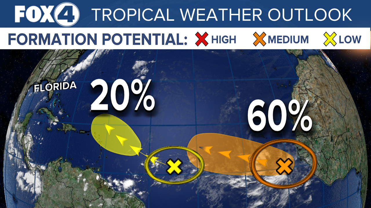
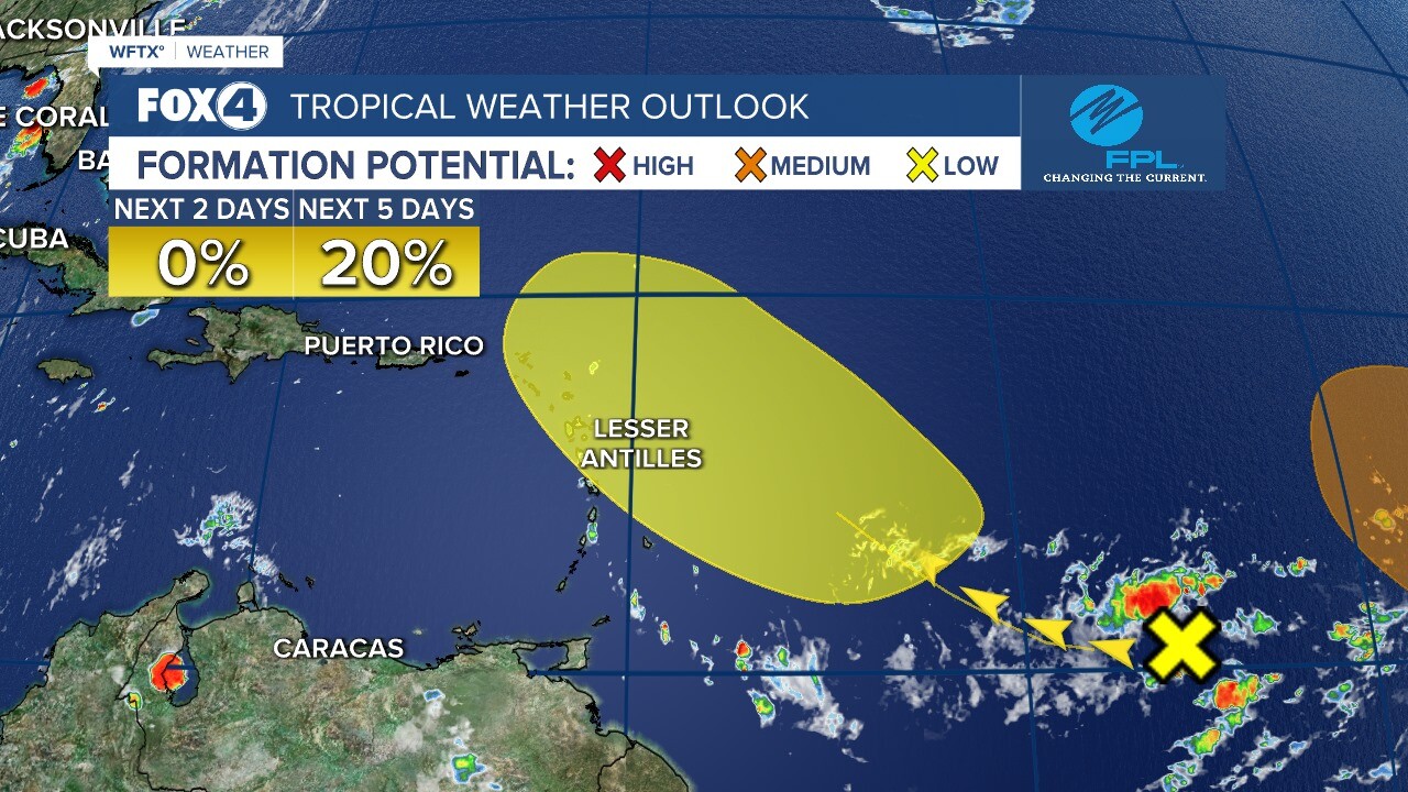
The second is an area of disorganized showers and thunderstorms that have changed little in association with an elongated low pressure area located several hundred miles east of the Lesser Antilles. Development of this system is becoming less likely during the next few days while it moves toward the west or west-southwest at around 10 mph.
Formation chance through 48 hours is low at 10 percent.
Formation chance through 5 days is low at 20 percent.

FOX 4 MORNING METEOROLOGIST TRENT ARIC
UPDATE 8/8/21 8 PM
The National Hurricane Center is monitoring two areas in the Atlantic.
An area of low pressure is located several hundred 400 miles ESE of the Leeward Islands and is producing disorganized showers and storms. Conditions will be conducive for further development as it makes its way toward the Lesser Antilles, the Virgin Islands, and Puerto Rico. It could become a tropical depression later in the week as it moves to the WNW at 15 mph. We will closely monitor these 2 waves as forecast models take this close to South Florida next weekend. It has a MODERATE chance of development over the next 5 days.
The second is an area of low pressure located over the central tropical Atlantic that continues to produce showers and thunderstorms. Environmental conditions are marginally conducive for further development, but a depression could still form later in the week as it moves WSW around 10 mph. Most forecast models dissipate the wave over the next couple days and some bring it close to South Florida. It has a MODERATE chance of development over the next 5 days.
FOX 4 METEOROLOGIST ERIC STONE
UPDATE 8/7/21 9 PM
The National Hurricane Center is monitoring three areas in the Atlantic.
The first is an area of disorganized showers and thunderstorms located a hundred miles SW of the Cabo Verde Islands. Environmental conditions are no longer conducive as upper level wind and cooler water will prevent this storm from gaining strength while the system moves WNW across the eastern tropical Atlantic. This system has a LOW chance of development over the next 5 days.
The second is a tropical wave located over the central tropical Atlantic that continues to produce some disorganized showers and thunderstorms. Slow development is possible early next week and a depression could form. This wave is drifting to the WSW. This system has a MODERATE chance of development over the next 5 days.
The third is a small area of low pressure in the west central tropical Atlantic. It is producing limited shower activity as it moves to the WNW at 10 to 15 mph and has a LOW chance of development over the next 5 days.
FOX 4 METEOROLOGIST ERIC STONE
UPDATE 8/7/21 3 PM
The National Hurricane Center is monitoring three areas in the Atlantic.
The first is an area of disorganized showers and thunderstorms located a hundred miles SSW of the Cabo Verde Islands. Environmental conditions are no longer conducive as upper level wind and cooler water will prevent this storm from gaining strength while the system moves WNW across the eastern tropical Atlantic.
This system has a LOW chance of development over the next 5 days.
The second is a tropical wave located over the central tropical Atlantic that continues to produce some disorganized showers and thunderstorms. Slow development is possible early next week and a depression could form. This wave is drifting to the WSW. This system has a MODERATE chance of development over the next 5 days.
The third is a small area of low pressure in the west central tropical Atlantic. It is producing limited shower activity as it moves to the WNW at 10 to 15 mph.
Formation chance through 48 hours is low near 0 percent.
Formation chance through 5 days is low at 10 percent.
FOX 4 METEOROLOGIST ERIC STONE
UPDATE 8/6/21 10 PM
The National Hurricane Center is watching three areas in the Atlantic for possible development. A wave south of the Cabo Verde Islands has the best chance of development with a 50% chance as it moves to the WNW.
A second wave is located about 1000 miles west of the Cabo Verde Islands and has a low chance of development over the next 5 days.
A third wave is located over 1000 miles to the southeast of the Lesser Antilles. It has a 10% chance of development over the next 5 days.
All three waves do not look impressive on satellite and do not appear to pose any threat on Southwest Florida.
UPDATE 8/6/21 5 PM
The National Hurricane Center is monitoring two areas in the Atlantic. The first is an area of disorganized showers and thunderstorms located a few hundred miles SSE of the Cabo Verde Islands. Environmental conditions appear somewhat conducive for gradual development, and a tropical depression is likely to form this weekend or early next week while the system moves WNW across the eastern tropical Atlantic. Forecast models take this system to the NE of our area posing no impact to Southwest Florida. It has a MODERATE chance of development over the next 5 days.

The second is a tropical wave located over the central tropical Atlantic that continues to produce some disorganized showers and thunderstorms. Slow development is possible early next week as the system moves WNW at 10-15 mph. It has a LOW chance of development over the next 5 days.

FOX 4 METEOROLOGIST ERIC STONE
UPDATE 8/6/21 8 AM
The National Hurricane Center is monitoring two areas in the Atlantic. The one with the highest chance of developing is coming off the coast of Africa and is located a few hundred miles south of the Cabo Verde Islands. It is a tropical wave interacting with a broader surface trough and environmental conditions appear somewhat conducive for gradual development over the next several days, and a tropical depression could form late this weekend or early next week while the system moves generally west-northwestward across the tropical Atlantic.
Formation chance through 48 hours is low at 30 percent.
Formation chance through 5 days is medium at 60 percent
The second area is a little closer to home over the central Atlantic. This is a trough of low pressure that continues to produce some disorganized showers and thunderstorms. This system is expected to move slowly west-northwestward, and some slow development is possible early next week as it approaches the Lesser Antilles.
Formation chance through 48 hours is low near 0 percent.
Formation chance through 5 days is low at 20 percent.
FOX 4 MORNING METEOROLOGIST TRENT ARIC
UPDATE 8/5/21 8 PM
The tropical wave located on the west coast of Africa now has a moderate chance of development over the next 2 days and a high chance over the next 5 as showers and storms continue. A depression is expected to form sometime this weekend. Forecast models are taking this to the WNW over the coming days so it looks like this will not impact SWFL, but we will continue to monitor this system.

There is a second wave along the African coast that is beginning to look a bit more impressive. This system has a moderate chance of development over the next 2 days and a high chance over the next 5 days. A tropical depression is expected to form this weekend, but does not look to pose any threat on SWFL.

FOX 4 METEOROLOGIST ERIC STONE
FIRST UPDATE 8/5/21 12 PM
NHC is watching two areas for tropical development in the Atlantic. There is a tropical wave west of the Cabo Verde Islands near 45° W a LOW chance for development. The other, a wave that is now moving off the African coast has a MEDIUM chance for development as it tracks west near the Cabo Verde Islands through late this week and this weekend. Conditions are only marginal for development with both systems due to dry air and dust from the SAL or Saharan Air Layer, with Invest 92 just off the African coast having the better chances for development in the near term.

The overall pattern favors a westward movement with a large high pressure cell over the center of the Atlantic that will steer both systems westward over the next few days. The lead wave at 45° W will turn northwest to just north of the Lesser Antilles early next week.
There are no immediate concerns about either wave becoming an eventual problem for the U.S. but we will continue to monitor them over the next few days.
FOX 4 CHIEF METEOROLOGIST DEREK BEASLEY
