

Here is your forecast for Sunday, August 9th, 2025.
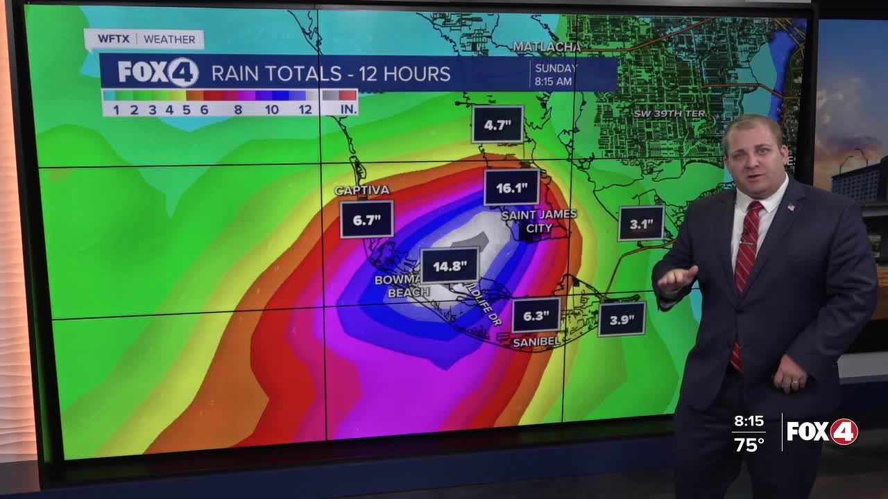
It has been a VERY wet start for our coastal communities, with Lee County barrier islands seeing flash flooding from 10+ inches of rainfall. Rain rates will decrease later in the morning, as showers and thunderstorms become more widespread. Still I wouldn't rule out localized 1-3 inches of rain possible throughout the day.
The cloud cover and rain will keep our temperatures around the mid to upper 80s.
Next week marks the first week of school for thousands of Southwest Floridians! Our classic rainy season pattern will return on Monday with morning sunshine and developing afternoon storms. High temperatures will therefore be a bit hotter, back to the mid-90s with head index values between 100-105°.
TROPICS:

A tropical wave near the Cabo Verde Islands has an 80% chance of developing into a tropical depression by the end of the week, according to the National Hurricane Center.
The system, Invest 97L, is currently located southeast of the Cabo Verde Islands, is showing increased shower and thunderstorm activity as environmental conditions appear favorable for further development.
Invest 97L is expected to move west-northwest at 15 to 20 mph across the eastern and central tropical Atlantic. If it strengthens into a tropical storm, it would be named Erin.
It's too early to determine the exact track of this system or any potential impacts to our Southwest Florida community. We'll have a clearer picture once a low-pressure center forms in the coming days.
Meanwhile, a second system, Invest 96L, in the central tropical Atlantic shows disorganized showers and thunderstorms. This trough of low pressure faces challenging conditions with surrounding dry air, giving it only a 20% chance of development over the next week as it moves northward.
I'll continue tracking these systems and bring you updates as new information becomes available.
If you don't already have our Fox 4 mobile app, you can download it here.
