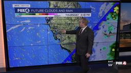


Here is your forecast for Thursday, February 5th, 2026.
It is a wet start in Southwest Florida as our next cold front arrives. Morning rain could slow down morning plans. Morning lows are starting in the low to mid-50s ahead of that front, and will warm into the mid 60s by 10am. That will be when we will see our daytime highs.
By lunchtime, the front will have moved through most of SWFL. You'll feel it come through your neighborhood as wind gusts pick up to 35 mph out of the northwest. This will drop temperatures into the 50s this afternoon.
This will then lead to a chilly start Friday with widespread 30s and low 40s across SWFL. Wind chills inland would drop as low as 29°. This will trigger a Cold Weather Advisory starting at 3am until 8am Friday morning for our inland areas.
Friday will feature lots of sunshine and gusts to 20mph, high temperatures will stay well below normal in the low 60s.
Looking ahead to the weekend, the mornings will be chilly staying in the upper 40s, but the afternoons will be fantastic with mostly sunny skies and highs in the low to mid 70s.
FOX 4 METEOROLOGIST ANDREW SHIPLEY
If you don't already have our Fox 4 mobile app, you can download it here.
